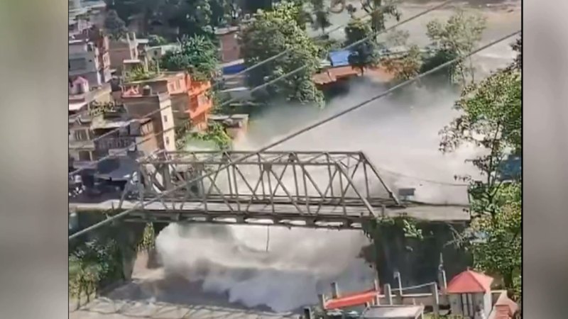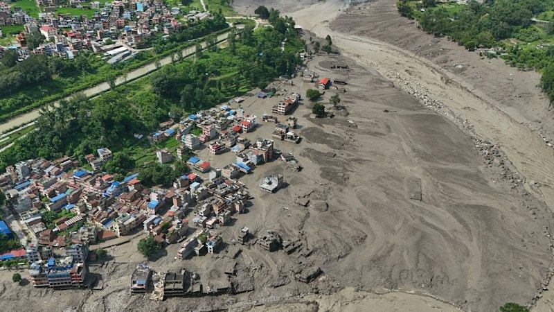
The catastrophic flash flooding along the Nepal-Tibet border region, resulting in more than 150 confirmed fatalities and hundreds of missing persons—including 34 Australian nationals—highlights systemic vulnerabilities in high-altitude hydrological management and transnational disaster response. This event is not merely an isolated weather anomaly; it is the physical manifestation of compounding geographical hazards, seasonal meteorological timing, and infrastructure stress points across the Trishuli and Bhote Koshi river corridors. Deconstructing the mechanics of this disaster reveals why traditional evacuation frameworks fail in narrow Himalayan gorges and how rescue logistics are dictated by hard physical limits.
The Physical Mechanics of High-Altitude Flash Floods
Understanding the sudden surge of water requires analyzing the upstream trigger points in the upper catchment areas. The disaster sequence was initiated by slope failures and ice or debris movements near the Tibetan border that rapidly constricted and then overwhelmed natural drainage pathways. When an obstruction of mud, rock, and ice gives way, it releases a massive hydraulic shockwave downstream. Meanwhile, you can read related developments here: Why the Nepal Border Flash Floods Left So Many Foreign Nationals Stranded.
The topography of the Rasuwa district and surrounding border zones features steep gradients and narrow river gorges. This topography functions as a natural acceleration channel. As the wall of water and debris surged down the Bhote Koshi and Trishuli basins, the volume increased exponentially by scouring riverbanks and entraining loose alluvial sediment.
Hydroelectric infrastructure situated along these corridors faced immediate structural overload. Run-of-the-river hydropower projects lack massive retention reservoirs capable of absorbing sudden volumetric spikes. Consequently, when the flood wave reached these installations, the facilities were structurally compromised, accelerating the downstream destruction of villages, roads, and bridges. To understand the full picture, check out the recent analysis by NBC News.
Transnational Demographic Exposure and Tourism Vulnerability
The high concentration of missing foreign nationals—including citizens from Australia, the United States, Britain, Canada, and Malaysia—directly correlates with seasonal tourism and pilgrimage patterns. The timing of the disaster coincided with high-volume travel periods, notably pilgrimages toward sacred sites such as Mount Kailash in Tibet, which routes travelers directly through Nepal's vulnerable northern border districts.
The structural vulnerability of these travelers is governed by three primary variables:
- Information Asymmetry: International tourists rely on localized tour operators and delayed weather advisories, creating a lag between meteorological shifts and evacuation actions.
- Infrastructure Bottlenecks: The region depends on linear transport arteries—specifically single-lane mountain roads and suspension bridges—which were severed early in the event, cutting off retreat options.
- Communication Blackouts: Destruction of cellular and local radio towers near the border created immediate information vacuums, preventing embassies and government bodies from confirming individual safety status in real time.
The Logistics Function of Search and Rescue Operations
Executing rescue operations in the Himalayan border zone involves severe operational constraints. Emergency response agencies, including the Nepal Army, Armed Police Force, and specialized local units, operate under strict environmental boundaries that limit the efficacy of standard deployment strategies.
Aviation assets represent the primary mechanism for accessing cut-off populations, yet helicopters face critical flight performance restrictions. High-altitude operations reduce engine efficiency, while ongoing adverse weather, low cloud cover, and swirling debris fields restrict pilot visibility. Furthermore, the absence of flat landing zones in gorges like Syapru Besi and Timure forces rescue teams to rely on hovering extractions or hazardous winch operations.
On the ground, heavy machinery cannot be deployed effectively until severed roads and destroyed bridges are temporarily bypassed or rebuilt. Ground search parties must navigate unstable terrain prone to secondary landslides, shifting the operational tempo from rapid extraction to methodical recovery.
Strategic Outlook for Regional Disaster Mitigation
Mitigating future mass-casualty events in high-risk Himalayan corridors requires a fundamental shift from reactive rescue to predictive infrastructure hardening. Cross-border hydrological data sharing between China and downstream nations like Nepal remains essential for providing early-warning telemetry before water volumes reach critical thresholds. Real-time seismic and river-gauge monitoring networks must be integrated with automated downstream alert systems tied directly to localized communication grids.
For international travel coordination, foreign ministries must enforce stricter real-time registry requirements for citizens undertaking high-risk trekking or pilgrimage routes in active monsoon zones. Tour operators functioning within these high-consequence environments must be bound by standardized emergency evacuation protocols that account for total infrastructure failure. The ultimate metric of success in these regions is not the speed of post-disaster retrieval, but the reduction of asset exposure before the hydrological threshold is breached.