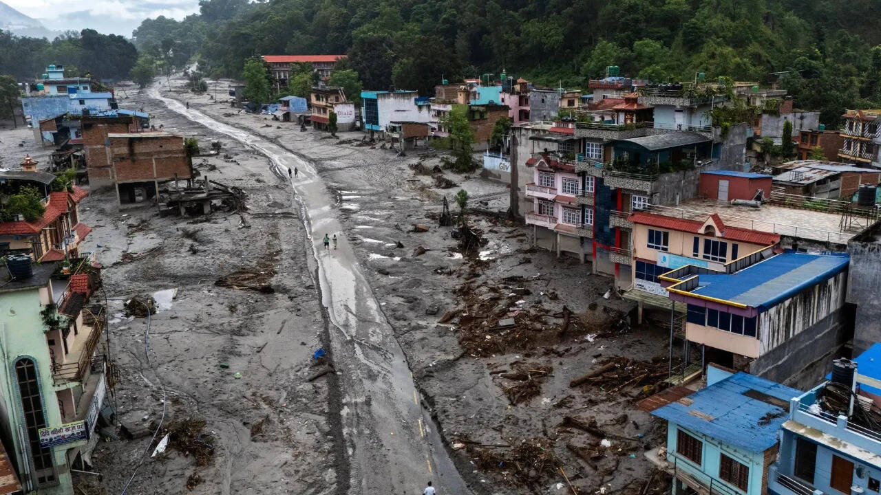
The catastrophic flash floods that struck the Nepal-Tibet border region on August 26, 2026, expose severe vulnerabilities in cross-border disaster response mechanisms, high-altitude infrastructure design, and early warning architecture. Triggered by a massive glacier collapse that sent an estimated 100 to 200 million cubic meters of ice, rock, and debris cascading down the Trishuli and Bhotekoshi river basins, the event resulted in over 780 confirmed fatalities and more than 3,000 missing individuals across both jurisdictions.
Analyzing the mechanics of this disaster requires moving past surface-level tragedy to examine the operational bottlenecks, logistical constraints, and systemic failures that transformed an environmental shock into a regional humanitarian crisis.
The Physical Trigger And Hydro-Geological Dynamics
The event originated at an altitude between 5,200 and 5,400 meters in the Himalayas, where a 0.2 square kilometer section of a glacier detached, dropping vertically by approximately 1.2 kilometers. Rather than a standard glacial lake outburst flood, this was a catastrophic structural ice avalanche.
The physical mechanics followed a distinct sequence:
- Immediate Kinetic Impact: The high-velocity mass impact converted potential energy into kinetic energy instantly, liquefying saturated debris and entraining millions of tons of sediment.
- Hydraulic Shockwave: The slurry entered narrow river gorges, creating an unmitigated hydraulic shockwave that bypassed traditional river-gauge thresholds before automated sensors could register volume anomalies.
- Infrastructure Impedance: Bridges, customs checkpoints at Gyirong Port, and run-of-the-river hydropower installations acted as temporary dams, momentarily pooling debris before structural collapse sent secondary flash waves downstream.
The absence of seismic precursors made advance warning nearly impossible. While seismic monitoring networks recorded the ground motion, the signals were initially misinterpreted or conflated with tectonic adjustments rather than cryospheric collapse. This highlights a critical monitoring blind spot: high-altitude cryospheric hazards require optical and radar satellite surveillance integrated with real-time acoustic sensors, as seismic networks alone cannot differentiate between rockfalls and ice avalanches in sufficient time to issue automated downstream alerts.
The Operational Cost Function Of Rescue Logistical Constraints
Search and rescue operations deployed nearly 20,000 security personnel in Nepal alone, alongside specialized units in Tibet. However, the efficiency of these deployments was crippled by severe operational constraints.
The rescue cost function can be expressed through three primary friction variables: terrain accessibility, communications blackout, and information asymmetry.
The verticality of the terrain restricted heavy machinery deployment during the initial 72 hours. Ground units relied on foot patrols and manual excavation while major arteries, such as the Kathmandu-Kodari highway, remained severed by landslides. Consequently, victim extraction depended almost entirely on vertical rotor-wing assets. Rotor operations faced severe density-altitude limitations, reducing payload capacities and restricting flight windows to narrow morning slots before high-altitude thermal winds destabilized flight paths.
Subsurface extraction presented an entirely different operational failure point. Hundreds of construction and operational workers were trapped inside subterranean tunnels at run-of-the-river hydropower projects, such as Trishuli 3A and 3B. Standard search and rescue protocols are structurally unequipped for subterranean mud-inundation events. Rescuers had to resort to mechanical drilling of small-diameter holes to insert air pipes and snake micro-cameras through compacted silt, turning a rapid rescue operation into a slow, high-risk engineering extraction project.
The Geopolitical Information Vacuum
Cross-border disaster response relies on real-time telemetry sharing. The upper catchment areas of these transboundary river systems lie within the Tibet Autonomous Region of China, while the high-impact zone of destruction is concentrated downstream in Nepal.
This geography created a structural divergence in reporting and response:
- Data Transparency vs. Information Control: While Nepalese authorities provided granular, daily accountings of casualties, missing foreign nationals, and rescue deployments, official reporting from the Tibetan side remained heavily restricted.
- Downstream Predictive Modeling Failures: Hydrological warning systems depend on upstream flow metrics. The tight control of information from upper-basin monitoring stations delayed precise volume projections for downstream Nepalese districts, cutting down reaction times for evacuation notices.
- Forensic and Resource Disparities: Nepal's emergency management infrastructure faced an immediate capacity deficit, explicitly requesting international assistance for DNA identification kits, specialized forensic pathology teams, and thousands of industrial freezer units to preserve human remains due to traditional cremation practices being overwhelmed. Conversely, Chinese state response assets possessed superior heavy engineering capabilities but operated behind an information firewall that prevented regional resource pooling.
Transboundary Early Warning System Architecture
Mitigating future events of this scale requires moving from reactive deployment models to predictive structural engineering frameworks. The vulnerability exposed along the Trishuli and Bhotekoshi corridors proves that decentralized, nation-state disaster management is obsolete for Himalayan river basins.
Future resilience depends on the implementation of three mandatory structural shifts:
- Automated Cryospheric Telemetry: Installation of continuous optical and radar monitoring arrays on high-risk hanging glaciers to track displacement velocities before structural failure occurs.
- Bilateral Data Fusion Centers: Establishment of a real-time, non-negotiable data-sharing treaty between upstream and downstream nations on transboundary river systems, stripping away information controls during hydrological emergencies.
- Subsurface Infrastructure Hardening: Retrofitting subterranean hydropower facilities in high-risk seismic and glacial zones with automated blast doors, independent emergency air scrubbers, and reinforced escape shafts designed to withstand sudden mud-slug inundation.
Deploy autonomous high-altitude sensor networks across upper-basin Himalayan zones linked directly to automated siren systems downstream, and establish binding international protocols for joint subsurface engineering responses before the next cryospheric collapse occurs.