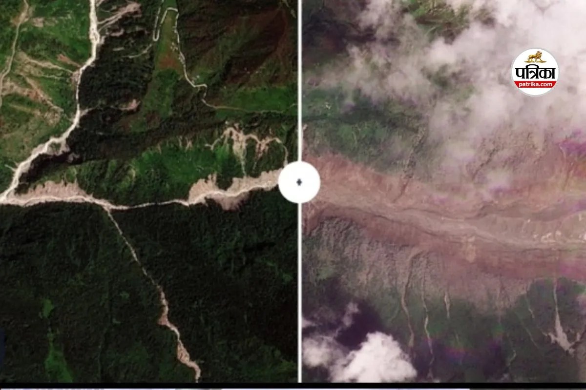
The transformation of the Himalayan terrain from stable green slopes to active debris flows within hours exposes the limits of current regional precipitation modeling. Understanding the Nepal flash flood 2026 event requires examining the intersection of extreme hydrological concentration, slope geotechnical failure thresholds, and downstream infrastructural vulnerability. This analysis deconstructs the structural mechanics behind the rapid mountain destabilization, maps the cascading failure points across affected river basins, and establishes the operational metrics necessary for evaluating future high-altitude hydro-meteorological shocks.
The Hydrological Trigger and Precipitation Concentration
Standard meteorological analysis often evaluates rainfall strictly through cumulative volume metrics over twenty-four-hour periods. That approach fails during localized convective bursts in high-relief topography. The 2026 flash flood sequence was driven by extreme sub-hourly precipitation intensity rates that saturated the upper soil mantle faster than subsurface drainage vectors could evacuate the water.
When precipitation rates exceed the infiltration capacity of topsoil, surface runoff velocity increases exponentially. In steep topography, this dynamic turns minor rills into high-energy transport channels. The volume of water acts less like liquid flow and more like a fluid piston, exerting hydrostatic pressure on fractured rock faces and loose colluvial deposits accumulated over previous seismic cycles.
The Vector of Soil Saturation
- Antecedent Moisture Conditions: Prior monsoon accumulation created high baseline saturation, reducing the matric suction that typically holds slope material together.
- Intensity Thresholds: Rainfall spikes exceeding 50 millimeters per hour breached the critical shear strength of shallow root networks on deforested or grazing-impacted inclines.
- Runoff Concentration: Narrow valley morphology forced disparate runoff streams into high-velocity convergence points, amplifying peak discharge volumes before warning systems could register the upstream mass balance shift.
Geotechnical Failure Mechanisms of Mountain Slopes
The visual shift from vegetated hillsides to bare debris fields is the surface manifestation of mass-wasting physics. Mountain slopes exist in a state of delicate equilibrium governed by gravitational pull, frictional resistance, and cohesion.
When water infiltrates colluvium, two physical changes occur simultaneously. Pore water pressure increases, which directly counteracts and reduces the effective normal stress holding the slope matrix in place. Simultaneously, the unit weight of the soil mass increases as voids fill with water. This dual mechanical shift transforms stable hillsides into liquefied debris masses.
The Three Phases of Debris Initiation
- Infiltration and Uplift: Water penetrates upper regolith layers, displacing trapped air and elevating pore water pressure along bedrock interfaces.
- Loss of Shear Resistance: Cohesion drops as fine-grained soil particles suspend in the saturated matrix, eliminating frictional interlocking between rock fragments.
- Translational Sliding to Fluidization: The entire upper mantle shears away along planar failure surfaces, instantly converting solid earth into a high-density slurry capable of transporting boulders weighing multiple tons.
Satellite Data and Observation Bottlenecks
Satellite imagery captured the aftermath of the 2026 disaster with stark clarity, yet orbital observation platforms exposed critical latency gaps in real-time disaster response architecture. Synthetic Aperture Radar and optical payloads effectively map scar zones, debris fans, and blocked river channels post-event, but they cannot prevent loss of life if down-link processing times exceed the velocity of the flood wave.
The speed of high-altitude debris flows often outpaces orbital repeat-pass intervals and cloud-penetrating data processing pipelines. While space-based assets provide vital macro-level damage assessments for insurance syndicates and federal recovery agencies, localized early warning relies on ground-based telemetry systems that are frequently destroyed in the initial wave of impact.
Remote Sensing Limitations
- Latency in Processing: High-resolution optical imagery requires daylight and cloud-free conditions, both of which are absent during active atmospheric river events.
- Spatial Resolution Trade-offs: Wide-swath radar can image through cloud cover but frequently misses micro-watershed slope failures that trigger larger downstream blockages.
- Ground-Truthing Deficits: Satellite signatures of land deformation cannot accurately measure the subsurface hydrology needed to predict the exact timing of slope collapse.
Downstream Infrastructural and Economic Vulnerability
The propagation of a debris flow through confined Himalayan river valleys creates a hydraulic battering ram effect. Bridges, hydropower installations, and human settlements built on historical alluvial fans face severe exposure because these landforms are, by definition, the product of past catastrophic floods.
Economic models that evaluate risk purely on historical flood return periods fail in a warming climate where precipitation extremes are decoupling from historical baselines. Infrastructure designed for a one-in-one-hundred-year flood event experiences structural fatigue when high-frequency moderate events alter riverbed cross-sections, raising the riverbed elevation and reducing channel capacity for subsequent seasons.
The Structural Vulnerability Matrix
- Hydropower Assets: Run-of-the-river intakes face immediate turbine destruction and penstock choking from high sediment loads and floating woody debris.
- Transportation Corridors: Highways hugging river gorges are vulnerable to toe erosion, where undercutting by swollen streams causes entire cliff-side roadbeds to collapse.
- Settlement Patterns: Ribbon development along river terraces maximizes accessibility but places populations directly within the high-energy deposition zone of lateral debris fans.
Institutional Preparedness and Tactical Adaptation
Mitigating future catastrophic failures in high-risk mountainous regions requires a transition from reactive disaster management to proactive geotechnical hardening and real-time sensor integration. Traditional flood walls and rigid engineering defenses often fail against high-energy debris flows because the kinetic energy of moving boulders exceeds the structural design limits of concrete barriers.
Effective adaptation strategies utilize nature-based solutions combined with distributed acoustic sensing networks. By monitoring micro-seismic vibrations caused by moving subsurface debris before surface sliding occurs, automated telemetry can trigger downstream sirens minutes before a flash flood crests. Furthermore, zoning laws must enforce strict setbacks from active alluvial fans, restricting permanent structural investments to geotechnically stable high benches.
Deploy decentralized, solar-powered low-latency river gauge networks linked directly to automated community alarm systems, while simultaneously restricting all permanent infrastructure placement within active debris fan deposition zones to eliminate exposure to high-energy mass-wasting events.