The physical map of the Himalayas is being violently rewritten, and the official casualty figures are only the opening ledger of a much deeper environmental collapse. In late August 2026, catastrophic flash floods roared down the rugged borderlands between Nepal and the Tibet Autonomous Region of China, claiming upwards of 800 lives in Nepal alone and leaving more than 3,000 individuals unaccounted for across the rugged terrain. Behind the shocking headlines of international tourists, local villagers, and hydropower workers swept away by wall-to-wall mud lies a systemic failure of high-altitude warning infrastructure. This disaster was not merely an act of angry weather; it was a predictable collision between accelerated glacial destabilization and unprepared modern development.
Decades of localized meteorological data show that the Hindu Kush Himalaya region is warming at a rate well above the global average. When an ice avalanche or glacial collapse triggered a sudden wall of water through the upper reaches of the Bhotekoshi and Trishuli river basins, the local monitoring network vanished almost instantly. The seismic and hydrological sensors deployed across the region were engineered to track predictable, seasonal monsoon swells. They were fundamentally blind to the high-velocity kinetic force of a sudden upstream outburst.
The Anatomy of a High-Altitude Blind Spot
Modern disaster response relies on lead time. When a glacial lake bursts or an ice wall fails at high elevations, downstream communities have minutes—sometimes hours—to scramble for higher ground, provided the warning apparatus holds. In this event, the early warning systems were wiped out before a single digital alert could ping the National Emergency Operation Centre in Kathmandu.
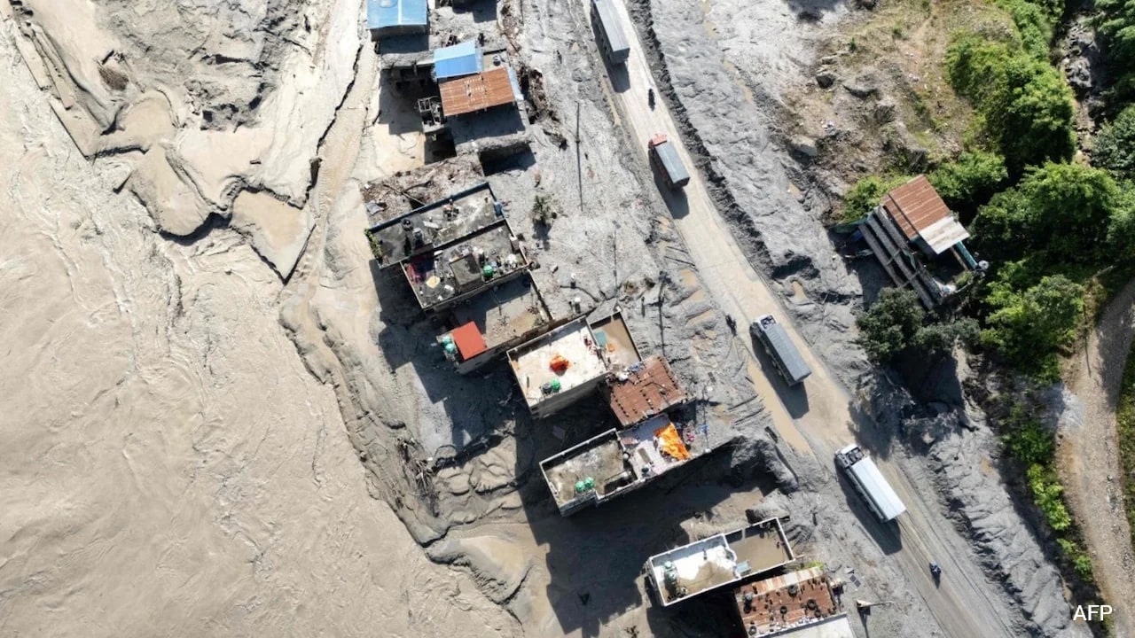
The physical mechanics of the catastrophe reveal a brutal reality. The wall of water carried entire chunks of mountainside, infrastructure, and infrastructure workers down narrow gorges with terrifying speed.
- Upstream hydrological monitoring stations were smashed to pieces within the first ninety seconds of the surge.
- Hydropower construction tunnels, meant to harness clean energy for the region, transformed into muddy death traps for hundreds of laborers.
- Remote border immigration checkpoints, such as Gyirong Port, were obliterated while crowded with domestic residents, foreign trekkers, and pilgrims moving toward sacred sites.
The sheer geography of the disaster zone complicates every facet of recovery. Rescue choppers battle volatile mountain winds and heavy cloud cover, dropping crews onto islands of mud where villages used to stand. Bodies have been recovered hundreds of kilometers downstream across the international border into India, carried by currents that refused to slow down long after leaving the high peaks.
The Human Toll Beyond the Numbers
While initial media reports focused heavily on the hundreds of missing foreign nationals—including travelers from the United States, India, Australia, and across Europe—the demographic reality of the missing paints a portrait of systemic economic vulnerability. Local subsistence farmers, seasonal hospitality workers, and domestic infrastructure contractors make up the vast bulk of the casualties.
Consider the workforce tied to the region's aggressive hydropower expansion. Independent power producers reported nearly a thousand workers missing or stranded across multiple project sites in the initial hours of the flood. For years, environmental analysts have warned that heavy industrial construction in narrow, seismically active Himalayan gorges creates localized ecological traps. When a flash flood hits a deep valley flanked by vertical rock walls, escape routes vanish. Workers inside underground tunnels or river-adjacent camps had virtually zero chance of outrunning a wall of debris moving faster than a commercial train.
Diplomatic scrambles followed the immediate crisis. Consulates from dozens of nations raced to reconcile conflicting rosters of hikers, spiritual pilgrims on the Mount Kailash trail, and expatriate engineers. Yet, these bureaucratic tallies often obscure the chaotic ground-level truth. Families thousands of miles away search social media feeds and TikTok uploads, tracing a missing relative's final known geotag in a village that no longer exists.
Rethinking Vulnerability in a Warming Range
Governments in Kathmandu and Beijing now face an uncomfortable reckoning. The frequency of high-altitude cryospheric anomalies is increasing. Higher temperatures mean more unstable ice fields, more precarious glacial lakes, and a higher probability of cascading mass-movement disasters. Traditional engineering standards, which treat historical flood levels as a reliable ceiling for future risk, are obsolete.
Rebuilding the shattered roads, bridges, and energy grids along the northern border will require billions of dollars, but financial capital alone cannot buy safety. Without a complete redesign of high-altitude hazard detection—moving away from fragile river-level sensors toward satellite-based radar monitoring and real-time slope stability analysis—the region remains trapped in a reactive cycle of rescue and recovery. Until policy catches up with the physical reality of a melting mountain range, every rainy season will carry the threat of another invisible catastrophe waiting to drop from the peaks.