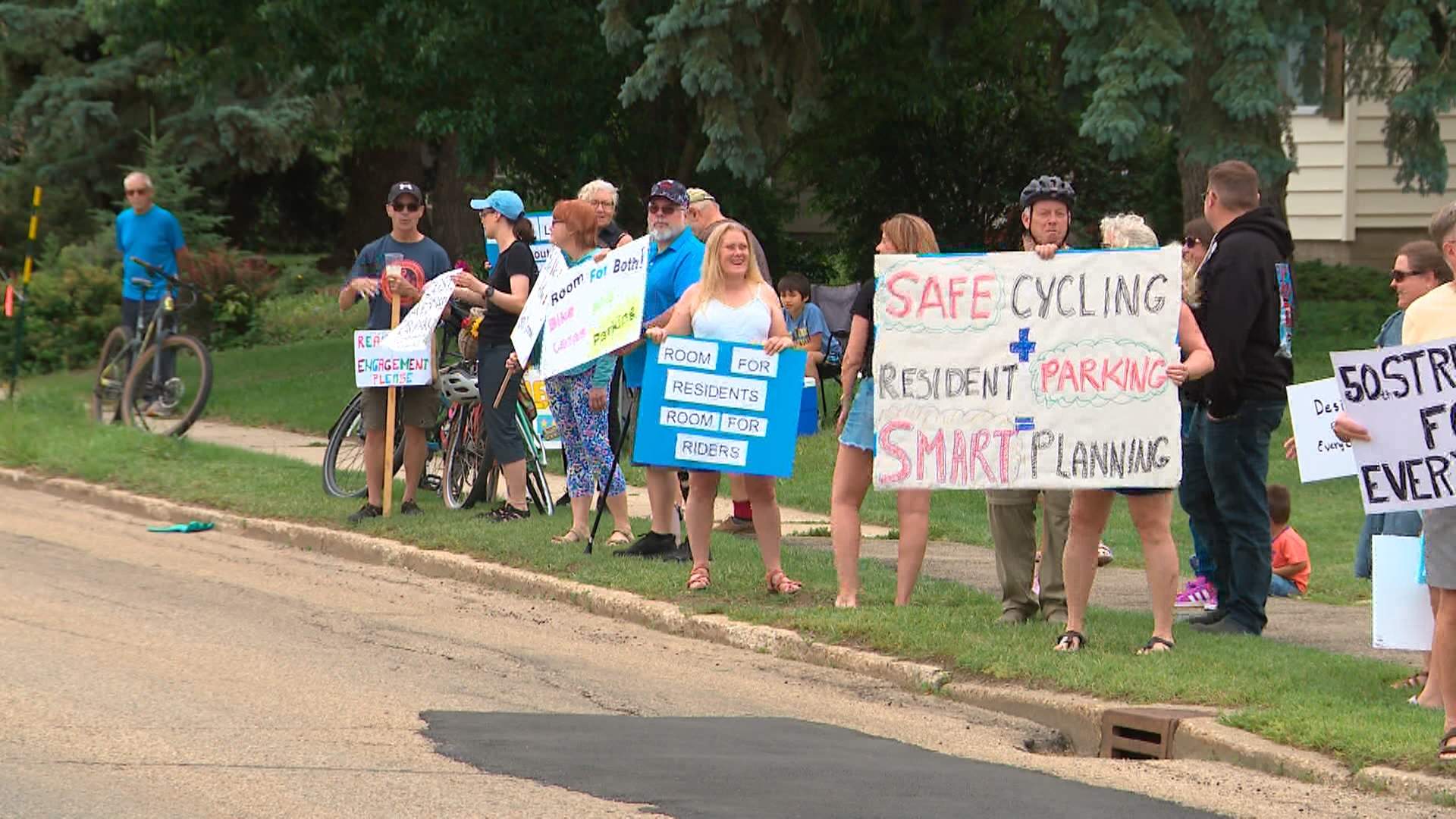
Municipal right-of-way reallocations fundamentally represent a zero-sum conflict between competing urban utilities. When the City of Edmonton altered its Active Transportation Network Expansion plans along 50th Street on July 7, 2026, the pivot exposed a systemic flaw in municipal infrastructure planning: the failure to model curbside utility curves before executing capital deployment. By analyzing the structural friction between micro-mobility corridors and residential curbside storage, cities can map the precise economic and operational boundaries of urban transit modifications.
The 50th Street corridor—spanning 102nd Avenue to 109A Avenue through the Capilano, Gold Bar, and Fulton Place neighborhoods—serves as an illustrative case study for the hidden costs of rapid active transit implementation. The original administrative design sought to maximize cycling safety metrics by completely eliminating on-street vehicle storage. However, organized community pushback forced city council to vote for a structural amendment. The resulting compromise reallocates portions of a 10-meter-wide central median to preserve 50% of the existing curbside parking, escalating the project cost from an initial $4.2 million to $4.9 million. This $700,000 variance highlights the financial premium cities pay when structural engineering is leveraged as a retroactive patch for social friction.
The Dual-Utility Conflict Framework
Urban roadways function simultaneously as transit corridors and static storage networks. The conflict on 50th Street emerges directly from the overlapping demands of these two distinct structural profiles.
       [ Total Right-of-Way Width: Variable ]
 ___________________________________________________
| Vehicle |  Curbside Parking   |  Active Transit   |
| Travel  | (Static Storage vs. | (Micro-mobility/  |
|  Lanes  |  Home Services Area)|  Safety Corridor) |
|_________|_____________________|___________________|
The Static Storage Function
For residential properties lacking front driveways, the curb is not a luxury option; it is a vital functional component of the property's logistics network. In mature developments built during the late 1950s and early 1960s, local topographical constraints create severe logistical bottlenecks:
- Topographical and Architectural Mismatch: In terraced river-valley topographies, many homes lack rear alley access. Where laneways exist, mid-century detached garages are architecturally incompatible with modern vehicle dimensions, rendering rear static storage useless for full-sized utility or family vehicles.
- The Last-Mile Service Vector: Curbside parking operates as the primary terminal point for essential modern service flows, including e-commerce fulfillment, app-based ride-hailing platforms, emergency medical services, and specialized home-care assistance for aging populations. Eliminating this terminal zone displaces these service vehicles into narrow rear lanes, creating severe localized traffic congestion.
The Micro-Mobility Transit Function
Conversely, the active transportation framework prioritizes a "Level of Traffic Stress 1" (LTS 1) rating. To build a network accessible to all ages and abilities, planners must separate vulnerable road users from heavy vehicular traffic volumes.
On 50th Street, this design goal was pursued by converting vehicle space into a protected active transit lane. When static vehicle storage is removed to make way for active transit, the immediate result is an optimization of moving lanes at the direct expense of residential logistics. This creates an immediate operational deficit for property owners along the route.
The Cost Function of Retroactive Engineering
When municipal administrations bypass localized spatial modeling, the mid-project corrections that inevitably follow incur a substantial capital premium. The financial shift in Edmonton’s 50th Street budget illustrates this planning penalty.
| Optimization Metric | Original Design Profile | Amended Design Profile |
|---|---|---|
| Capital Expenditure | $4.2 Million | $4.9 Million |
| Curbside Storage Retention | 0% | 50% (106 Ave to 109A Ave) |
| Median Infrastructure Impact | Zero Modification | 1 to 2-Meter Reduction |
| Vehicle Throughput Lanes | Two Lanes Maintained | Two Lanes Maintained |
The structural mechanisms driving the $700,000 expenditure increase are driven by specific engineering demands:
Median Modification and Utility Relocation
The initial plan treated the 10-meter central median as static, non-functional space, opting instead to extract right-of-way width directly from the curb. The amended plan reverses this choice, taking 1 to 2 meters from the landscaped median to make room for both parking and bike lanes. Shifting the roadway boundary inward requires removing mature green infrastructure, re-grading the road bed, adjusting stormwater catch basins, and relocating buried or overhead municipal utility linkages.
Design Re-Engineering Overhead
Halting construction to re-draft engineering plans creates immediate financial waste. Sunk costs from the initial design phase cannot be recovered, and contractors charge premium standby rates while waiting for updated construction blueprints.
Fragmented Logistical Deployments
The amended plan splits the corridor into two distinct structural styles: the northern half retains parking by cutting into the median, while the southern half follows the original curb-elimination design. This fragmentation limits the savings usually gained from uniform, large-scale construction, as crews must constantly switch equipment setups and construction techniques along the route.
Misalignment in Consultation and Communication
The breakdown on 50th Street reveals a profound disconnect between macro-level city policies and neighborhood-level realities. The City of Edmonton relied on data collected during the high-level engagement phases for the 2020 Bike Plan and The City Plan. While these broad surveys show strong city-wide support for climate resilience and active transit networks, they consistently fail to account for the specific spatial needs of individual blocks.
[City-Wide Strategic Vision]
       │ (High-level policy approval for active transit goals)
       ▼
[Localized Spatial Realities]
       │ (Individual block constraints: mid-century garages, topography)
       ▼
[Implementation Friction]
       (Unpredicted project resistance and retroactive budget inflation)
This reliance on high-level data creates a structural blind spot. A city-wide resident may favor adding 33 kilometers of active transit infrastructure in the abstract, but that general support erodes when an individual homeowner discovers that their specific residence will lose its delivery and home-care access zone.
By treating broad policy goals as a blanket mandate for specific design plans, the city overlooked crucial local details, such as the 30 vehicles regularly parked on that specific stretch of 50th Street. This data gap triggered a sharp, organized community protest that quickly halted construction.
Quantifying the Value of 30 Parking Stalls
The opposition to the budget increase focuses directly on resource allocation. Critics point out that spending an extra $2.5 million across multiple disputed bike routes just to save 30 parking stalls on 50th Street represents an incredibly high cost per stall.
To evaluate this investment objectively, cities must look beyond simple construction costs and analyze the long-term economic trade-offs:
Asset Depreciation vs. Capital Outlay
If removing front parking lowers the value of the 200 adjacent homes by even 1.5% due to reduced accessibility, the total loss in neighborhood property value quickly matches or exceeds the $700,000 engineering premium. This property depreciation directly impacts the city's long-term property tax revenue model.
Externalized Costs to Public Services
Eliminating curbside access forces delivery drivers, paratransit vehicles, and home-care nurses to park illegally or block narrow back alleys. The resulting delays in home-care delivery and the increased risk of minor collisions create real economic costs that are passed directly onto residents and provincial service budgets.
Political and Legislative Risk
This local infrastructure friction has broader political consequences. The province of Alberta has signaled plans to introduce legislation giving the provincial government greater power to review or remove municipal bike lanes. Failing to find a local compromise risks triggering top-down provincial interventions that could jeopardize the city’s entire $100-million active transportation portfolio.
Strategic Recommendation
To avoid costly mid-project corrections and structural planning failures in the future, municipal transport authorities must move away from top-down design models and adopt a clear, data-driven framework for reallocating right-of-way space.
1. Screen Local Topography & Architectural Limits
   (Check alley access, garage dimensions, slope constraints)
           │
           ▼
2. Analyze Real-Time Curbside Demand
   (Measure overnight parking density and service vehicle stops)
           │
           ▼
3. Run Context-Specific Engineering Feasibility
   (Evaluate median options and utility adjustments BEFORE budgeting)
First, cities should run a mandatory localized filter before finalizing any infrastructure designs. This means checking physical constraints—such as garage sizes, alley access, and property slopes—along with real-world curbside usage patterns before choosing a standard design template.
Second, project budgets must explicitly include the cost of median adjustments right from the start whenever a route runs along a wide, boulevard-style road. Treating central medians as flexible space rather than unchangeable borders allows planners to preserve parking and build protected bike lanes simultaneously, avoiding the public backlash and retrofitting costs seen on 50th Street.
Finally, public consultation must shift from abstract, high-level policy surveys to clear, block-by-block design reviews. Presenting clear trade-offs early in the process allows cities to find viable compromises before dispatching construction crews, ensuring capital is deployed efficiently and sustainably.