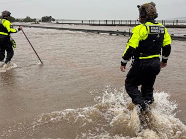
Heavy precipitation events in Texas are not merely anomalous weather incidents; they represent a predictable breakdown of hydrological and civil engineering systems under specific thermodynamic and geologic constraints. When intense downpours strike South Texas and the Hill Country, the resulting inundation is the mathematical consequence of atmospheric moisture loading, prolonged meteorological stagnation, and soil mechanics that limit infiltration. Analyzing these systems through structural physical frameworks reveals why standard municipal drainage systems fail and how risk-mitigation models must adapt.
The Thermodynamic Driver of Atmospheric Moisture Loading
The primary physical constraint governing extreme precipitation is the water-vapor carrying capacity of the atmosphere. This relationship is mathematically defined by the Clausius-Clapeyron equation, which dictates the saturation vapor pressure $e_s$ as a function of temperature $T$:
$$e_s(T) = e_0 \exp\left(\frac{L_v}{R_v} \left(\frac{1}{T_0} - \frac{1}{T}\right)\right)$$
Where:
- $L_v$ is the latent heat of vaporization of water ($2.5 \times 10^6 \text{ J/kg}$).
- $R_v$ is the specific gas constant for water vapor ($461.5 \text{ J/(kg}\cdot\text{K)}$).
- $T_0$ is a reference temperature (273.15 K) and $e_0$ is the saturation vapor pressure at $T_0$ (611 Pa).
This thermodynamic relationship yields an approximate $7%$ increase in the atmosphere’s moisture-holding capacity for every $1^\circ\text{C}$ rise in ambient temperature. When warm, saturated air masses migrate from the Gulf of Mexico into continental Texas, they carry an elevated precipitable water (PWAT) load.
During extreme storm systems, atmospheric sounding profiles frequently record PWAT values exceeding $2.0 \text{ inches}$, representing the upper limit of climatological norms. Under these conditions, the total mass of precipitable water suspended in the atmospheric column is sufficient to yield catastrophic localized downpours if an appropriate lifting mechanism triggers condensation.
Meteorological Stagnation and Trigger Mechanisms
High precipitable water values alone do not cause catastrophic flooding; a secondary atmospheric mechanism must continuously trigger condensation and anchor the storm system over a fixed geographic area. This stalling occurs through two primary structures:
The Mesoscale Convective Vortex
A Mesoscale Convective Vortex (MCV) is a warm-core, low-pressure system that develops within a decaying mesoscale convective complex. Ranging from 30 to 150 miles in diameter, these vortex structures can persist for several days after their parent thunderstorm has dissipated.
Because upper-level steering winds during summer months are weak—often due to the northward retreat of the polar jet stream—the MCV becomes stationary. This cyclonic circulation acts as a continuous localized pump, drawing in high-theta-e (warm, moist) boundary-layer air from the Gulf of Mexico. The rotation provides the sustained vertical velocity required to condense the incoming moisture stream, creating a localized conveyor belt of precipitation.
Frontal Boundary Anchoring and Back-Building
When a weak, slow-moving cold front stalls across central or southern Texas, it serves as a wedge for incoming tropical air. As warm moist air from the south hits this stationary boundary, it is forced upward, condenses, and forms convective storm cells.
If the ambient wind vector parallel to the frontal boundary matches the propagation speed of the individual storm cells in the opposite direction, "train-echoing" occurs. The convective cells pass over the exact same geographic footprint sequentially, accumulating extreme precipitation totals over narrow corridors.
Hydrological Infiltration and Runoff Mechanics
Once precipitation reaches the surface, the transition from rainfall to surface runoff is governed by the water balance equation:
$$P = ET + Q + \Delta S$$
Where:
- $P$ is precipitation rate.
- $ET$ is evapotranspiration.
- $Q$ is runoff.
- $\Delta S$ is the change in soil storage.
During rapid-onset convective storms, evapotranspiration is negligible ($ET \approx 0$). The volume of runoff $Q$ is therefore determined entirely by the rate of change in soil storage $\Delta S$, which is controlled by the soil infiltration capacity. This process is modeled by the Green-Ampt infiltration equation:
$$f(t) = K_s \left(1 + \frac{\psi (\theta_s - \theta_i)}{F(t)}\right)$$
Where:
- $f(t)$ is the infiltration rate.
- $K_s$ is the saturated hydraulic conductivity of the soil.
- $\psi$ is the wetting front soil suction head.
- $\theta_s$ is the saturated soil moisture content.
- $\theta_i$ is the initial soil moisture content.
- $F(t)$ is the cumulative infiltration depth.
This model reveals two distinct failure modes within Texas soils:
The Saturated Boundary Limit
When antecedent rainfall has already saturated the upper soil layers, the initial moisture content approaches the saturated content ($\theta_i \approx \theta_s$). Under this condition, the term $(\theta_s - \theta_i)$ approaches zero.
The infiltration rate collapses to equal the saturated hydraulic conductivity ($f(t) \approx K_s$). If the rainfall rate $P$ exceeds $K_s$, all excess precipitation is converted directly into surface runoff $Q$:
$$Q = P - K_s$$
Because clay-rich soils common in parts of Texas have exceptionally low saturated hydraulic conductivities ($K_s \approx 0.01 - 0.05 \text{ inches/hour}$), flash flooding occurs almost immediately once saturation is achieved.
The Desiccated Hydrophobic Barrier
The inverse scenario occurs during severe droughts, a phenomenon known as weather whiplash. When soils remain dry for extended periods, clay minerals shrink and bake, forming an impermeable, compacted crust.
Hydrophobic organic compounds can coat the dry soil particles, preventing water from wetting the surface. In this state, the wetting front soil suction head $\psi$ is temporarily restricted because water cannot penetrate the compacted layer. Until the soil is thoroughly wetted, the effective infiltration rate drops to near-zero, causing intense rainfall to run off dry ground as if it were concrete.
Topographic and Structural Amplification
The geography of Texas features unique structural corridors that amplify water velocity and volume, most notably the Edwards Plateau and the Balcones Escarpment, frequently referred to as "Flash Flood Alley."
                       BALCONES ESCARPMENT
   Edwards Plateau         (Fault Zone)             Gulf Coastal Plain
  [Thin Soil/Karst]             \
   ===============\              \
                   \              \               =================
                    \              \_____________/  Urban Runoff
                     \              \            \ [Impervious Cover]
                      \              \            \________________
                       \              \                             \
                        \   Creek      \     Swollen River           \
                         \  Funneling   \                             \
Karst Geomorphology
The Edwards Plateau consists of thin layers of clayey soil overlying fractured limestone (karst topography). The soil layer, often only a few inches deep, reaches its storage capacity $\Delta S$ within the first few minutes of a storm.
Below this thin soil, the limestone bedrock is highly impermeable at the surface, preventing deep percolation. Instead of absorbing water, the network of steep limestone hills and narrow, eroded canyons acts as a physical funnel. Runoff is rapidly concentrated into dry creek beds, accelerating water velocities and transforming small streams into raging torrents in less than an hour.
Impervious Surface Urbanization
In rapidly expanding urban centers like San Antonio, Austin, Houston, and the Rio Grande Valley, natural soils are replaced by asphalt and concrete. This creates a permanent structural barrier where infiltration is zero ($f(t) = 0$).
The entire volume of precipitation is immediately converted into surface runoff. Because engineered concrete channels have lower roughness coefficients than natural creek beds, water velocities increase, leading to shorter time-to-peak concentration waves at downstream junctions.
Infrastructure Capacity Failures and Civil Engineering Limitations
Civil drainage infrastructure is designed based on historical statistical return periods, commonly referred to as the 10-, 50-, or 100-year storm events. These return periods rely on localized Intensity-Duration-Frequency (IDF) curves.
A major systematic vulnerability in current infrastructure planning is stationarity—the assumption that historical precipitation distributions accurately predict future probability curves.
Climate shifts and thermodynamic warming have rendered these historical IDF curves obsolete. A storm event classified as a 100-year event under mid-20th-century datasets may now exhibit a statistical recurrence interval of 20 or 30 years.
Furthermore, municipal drainage networks are structurally constrained by hydraulic capacity. Gravity-fed storm sewers, culverts, and retention basins are sized using the Rational Method:
$$Q_p = C \cdot I \cdot A$$
Where:
- $Q_p$ is the peak runoff rate ($\text{ft}^3/\text{s}$).
- $C$ is the dimensionless runoff coefficient.
- $I$ is the rainfall intensity ($\text{in/hr}$).
- $A$ is the drainage area ($\text{acres}$).
If the localized rainfall intensity $I$ exceeds the design threshold used to calculate the capacity of the receiving system, water backs up at the inlets. This creates localized surcharge conditions where storm sewers reverse flow, flooding roadways and structures from the underground network upward.
Strategic Adaptation Paradigms
Traditional flood mitigation has relied on gray infrastructure—dams, concrete channels, and seawalls designed to transport water away from assets as rapidly as possible. This approach merely shifts the peak hydraulic load downstream, exacerbating flooding in adjacent districts. Modern engineering strategies must transition toward a distributed, adaptive system.
Municipalities must adopt dynamic IDF curves that incorporate thermodynamic projection models rather than relying solely on historical baselines. These updated models must dictate minimum retention basin capacities for all new commercial and residential developments.
Implementing localized detention reservoirs capable of temporarily storing excess runoff volume ($Q$) allows communities to control the discharge rate, matching it to the hydraulic capacity of the receiving natural streams.
Simultaneously, retrofitting urban spaces with permeable pavements, bioswales, and rain gardens increases the net infiltration rate ($f(t)$) across the metropolitan footprint, systematically lowering the peak runoff rate ($Q_p$) at its source.