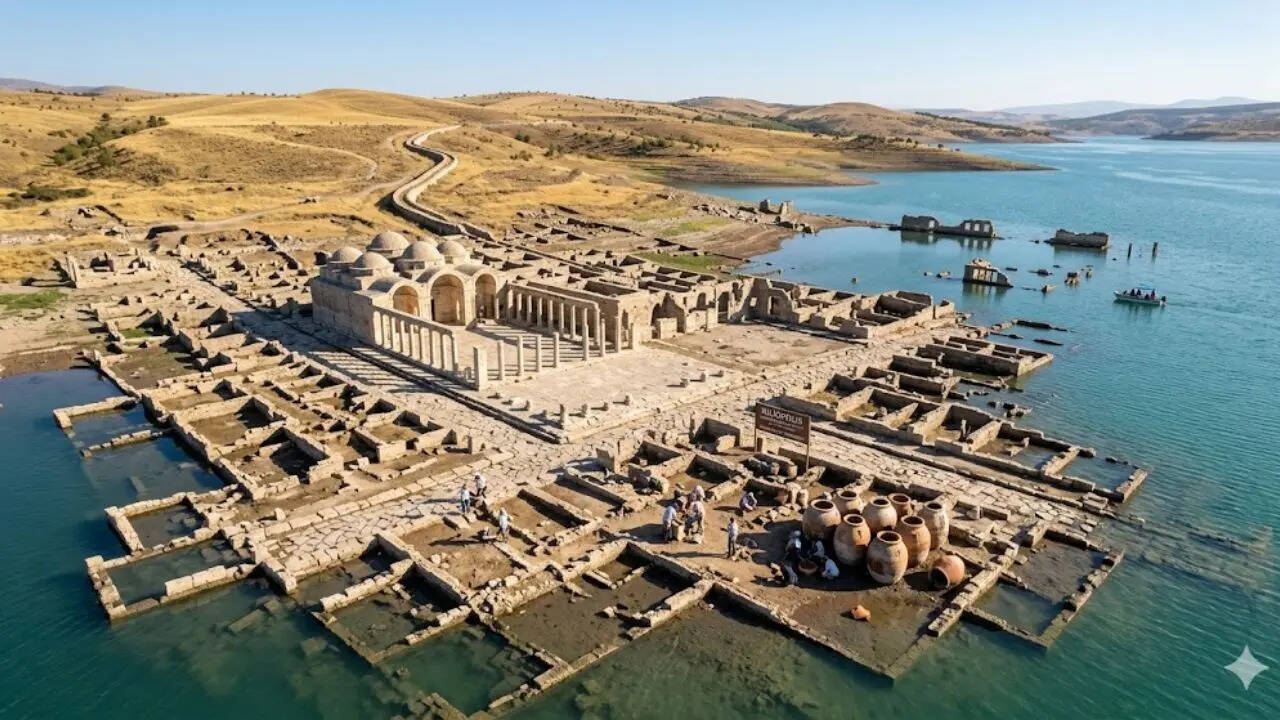
The discovery of submerged urban structures off the coast of Turkey, dating back approximately 2,000 years, represents more than a maritime curiosity; it is a case study in Hydro-Urbanism. These sites, particularly those identified in the Kerpe and Kekova regions, demonstrate a sophisticated grasp of littoral engineering that prioritized resource management and logistics over mere proximity to the sea. The preservation of these ruins allows for a forensic reconstruction of ancient urban planning, revealing a deliberate alignment between topographic constraints and economic utility.
The presence of organized street grids, quay systems, and breakwaters beneath the surface indicates that these were not accidental settlements overtaken by rising tides, but rather highly specialized maritime hubs. Their survival provides the empirical data necessary to analyze the three structural pillars of ancient coastal resilience: Hydraulic Integration, Logistical Efficiency, and Geomorphological Adaptation.
The Mechanics of Hydraulic Integration
The primary challenge for any coastal city in antiquity was the management of water—both as a resource and a threat. The Turkish underwater sites reveal an advanced understanding of the Fluid Dynamics of Coastal Buffering. Unlike modern concrete-dependent structures, these cities utilized local materials to create permeable barriers that absorbed wave energy rather than resisting it through brute force.
The Breakwater Cost Function
The construction of breakwaters served a dual purpose: sediment management and vessel protection. By calculating the depth and orientation of these submerged stone walls, we can infer the prevailing wind patterns and sea levels of the Roman and Byzantine periods. The "Cost Function" of these structures was high, requiring the quarrying and transport of massive limestone blocks. The decision to invest in such infrastructure confirms the site’s status as a high-value node in the Mediterranean trade network.
Aqueduct and Cistern Networks
Urban density in these coastal zones was capped by the availability of potable water. The submerged ruins show integrated cistern systems designed to capture runoff. This creates a clear cause-and-effect relationship:
- Infrastructure: Stone-lined channels and vaulted cisterns.
- Capability: Support for a permanent, non-agrarian population.
- Outcome: The transition from a seasonal fishing outpost to a permanent commercial port.
Logistical Efficiency and the Maritime Grid
Analysis of the underwater street layouts suggests that urban planning was dictated by the Logistics of Displacement. Standard inland cities typically utilized a cardo and decumanus grid for infantry and chariot movement. In these submerged Turkish cities, the grid is noticeably skewed toward the waterfront.
The Quay-to-Core Ratio
The efficiency of an ancient port can be measured by the distance between the quay (unloading zone) and the commercial core (market or horreum). In the Kerpe excavations, this distance is minimized through a radial design. This structural choice reduced the man-hours required for stevedoring, effectively lowering the overhead for merchants. The logical framework here is one of Throughput Optimization: the faster a vessel could be turned around, the higher the port's tax revenue and economic viability.
Storage and Modular Architecture
The remains of amphorae found within building foundations suggest that structures were often modular. Warehouses were built with standardized dimensions to accommodate the standard Mediterranean shipping containers of the era. This reveals a level of economic synchronization across the region; the city was not just an isolated settlement but a physical interface for a standardized global trade system.
Geomorphological Adaptation and the Tectonic Variable
A significant portion of the "advanced" nature of these cities lies in their response to seismic activity. Turkey’s coastline is defined by the North Anatolian and Hellenic arcs, making it one of the most tectonically active regions in the world. The submergence of these cities is largely attributed to Tectonic Subsidence rather than a simple rise in global sea levels.
Seismic-Resistant Foundations
Archaeological mapping shows that foundations were often cut directly into the bedrock or utilized "ashlar" masonry with dry-joint techniques. This allowed for a degree of flexibility during tremors. The collapse of these cities was rarely the result of a single catastrophic event, but rather a series of gradual subsidence cycles that eventually rendered the quay systems unusable.
The Transition of the Waterline
As the land sank, the urban logic shifted. We see evidence of "uplifting" where secondary floors were converted into primary entrances, and new quays were built atop submerged ones. This demonstrates a Reactive Planning Cycle:
- Phase 1: Stabilization. Traditional coastal building.
- Phase 2: Encroachment. Rising water levels necessitate the fortification of lower levels.
- Phase 3: Abandonment. The logistical cost of maintaining dry transit exceeds the economic output of the port.
Quantifying the Archaeological Data Gap
While the visual evidence of underwater columns and sarcophagi is compelling, the data is currently limited by the Erosion Constant. Saltwater and current-driven abrasion degrade the fine details of inscriptions and decorative elements, which would otherwise provide specific dates for municipal reforms or shifts in governance.
The current analytical model relies on:
- Ceramic Chronology: Using pottery shards to establish a timeline of occupation.
- Photogrammetry: Creating 3D digital twins of the seabed to measure architectural precision.
- Bathymetric Mapping: Understanding the original shoreline to reconstruct the city’s relationship with its environment.
The limitation of this data set is the "Taphonomic Bias." We are seeing only the most durable materials—stone and ceramic. The organic components of these cities—timber docks, sails, ropes, and market stalls—have vanished, potentially skewing our perception toward a more "static" or "monumental" urbanism than actually existed.
Strategic Economic Significance of the Turkish Coastline
The location of these cities was never arbitrary. They were positioned at the intersection of the Aegean-Levantine Corridor. The economic logic for these cities was predicated on three variables:
- Windward Protection: Deepwater bays that offered sanctuary from the Etesian winds.
- Resource Access: Proximity to timber for shipbuilding and minerals for export.
- Political Geography: Acting as buffer zones or "Emporia" between competing regional powers.
The collapse of these cities did not signal a failure of planning, but rather a failure of the environment to remain static. The sophisticated urbanism found in these 2,000-year-old ruins serves as a reminder that infrastructure is always a bet against geological time.
Current developers of coastal infrastructure should prioritize the Permeable Barrier Logic found in these ancient sites. Modern "hard" sea walls often accelerate erosion in adjacent areas through wave reflection. By contrast, the rubble-mound breakwaters of the Roman era dissipated energy through internal friction. The strategic takeaway for modern civil engineering is a return to Dissipative Design—building systems that work with the fluid dynamics of the ocean rather than attempting to override them through rigid containment.
The next phase of Mediterranean maritime archaeology must shift from discovery to Structural Modeling. By applying computational fluid dynamics to the 3D maps of these submerged cities, we can determine exactly how effective these ancient quay systems were at managing siltation. This will move the conversation from "ancient wonders" to "quantifiable engineering precedents," providing a blueprint for resilient coastal architecture in an era of increasing volatility.