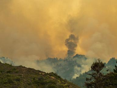
Driving down Highway 1 through Big Sur usually evokes thoughts of pristine ocean cliffs and towering redwoods. Right now, that scenic dream is choked in thick gray smoke. Two separate blazes are actively chewing through the rugged Monterey County coastline, turning a vacation paradise into a tactical nightmare for emergency crews.
The situation along California's central coast is brutal. The older Timber Fire has already scorched nearly 20,000 acres, earning its spot as one of the state's largest fires this season, while a newer threat, the Plaskett Fire, erupted rapidly in steep terrain. If you are tracking travel plans or monitoring family in the area, the reality on the ground is changing by the hour. Discover more on a similar issue: this related article.
Understanding the Double Threat on Highway 1
Managing one major wildfire in coastal California is tough enough. Managing two distinct incidents miles apart stretches local and federal resources to their absolute limits.
The Timber Fire has been burning since August 8, pushing north through roughly 31 square miles of bone-dry brush. Officials have managed to carve out around 21% containment, but over 660 structures remain directly threatened. Meanwhile, the Plaskett Fire broke out further south near Los Burros Road, scaling up quickly to 1,700 acres with zero containment. Further journalism by The Washington Post highlights related perspectives on the subject.
Highway 1 is completely fractured. Major segments of the iconic coastal route are shut down between Gorda and Old Coast Road. These closures are not just for public safety. Crews are using the highway as a strategic control line, parking heavy machinery and staging back-burning operations directly off the asphalt.
Why Big Sur Terrain Defeats Modern Firefighting
Most people assume firefighters can roll up to a blaze with a fleet of trucks and put it out. Big Sur laughs at that assumption.
The topography here is vertical and isolated. Ground crews often have to hike miles into vertical canyons where roads simply do not exist. When a fire establishes itself on a steep slope reversal—as the Plaskett Fire did—it feeds on dry timber and races uphill faster than a human can run.
Aircraft play a massive role, but they are entirely at the mercy of the weather. Six helicopters and multiple fixed-wing water droppers have been cycling through smoke-filled canyons. When wind gusts pick up or visibility drops, the planes are grounded. That leaves ground teams to fight walls of heat with hand tools, chainsaws, and sheer grit.
Evacuations and What Residents Face Now
Evacuation orders and warnings are active across Monterey County. Living along this stretch of coast means accepting a high degree of isolation, but it becomes a severe liability when disaster strikes.
Residents are facing immediate hard choices. Pack up pets, livestock, and heirlooms, or risk getting trapped behind road closures and rapidly shifting fire fronts. Officials with the California Interagency Incident Management Team are coordinating structure defense, prioritizing homes by clearing defensible space and wrapping vulnerable properties in fire-resistant materials.
If you are planning a trip along the Pacific Coast Highway anytime soon, cancel it. Check Caltrans updates before thinking about heading anywhere near Monterey County, and respect every single road closure. Crews need open asphalt to move bulldozers and water tenders, not tourists looking for photos of the smoke.