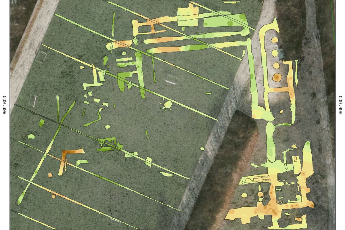
An underground parking garage proposal in Roskilde, Denmark, has inadvertently mapped the complete skeletal outline of St. Clare's Convent, a 13th-century monastic complex previously written off by historians as entirely obliterated. Roughly one meter beneath a standard municipal football pitch at Byparken, ground-penetrating radar operated by a joint Danish and Norwegian archaeological team revealed four distinct monastic wings, internal room divisions, a cloister, and a southern church wing. The find upends decades of institutional assumptions about urban medieval archaeology and exposes the precarious friction between modern municipal infrastructure and the ghost architecture buried beneath our feet.
The Myth of Complete Destruction
Generations of scholars accepted a tidy narrative of total erasure for St. Clare's Convent. Founded in 1256, the institution served as a powerful spiritual and royal anchor during the medieval zenith of Roskilde. When the Protestant Reformation swept through the region in the 16th century, Catholic properties were dissolved, systematically dismantled, and repurposed.
Historical accounts indicate that workers hauled away upwards of half a million bricks from the convent to fuel construction projects at nearby Selsø Castle. Because the stripping of building materials was so thorough, local historians operated under the persistent belief that nothing of structural value remained.
That assumption ignored how medieval builders laid their foundations. Brick-robber trenches and surface salvage rarely strip footings lying deeper than the plow zone or modern grading layers. By treating historical demolition records as absolute truths rather than biased administrative tallies, researchers missed the subterranean reality. The upper stories vanished into aristocratic manors, but the load-bearing masonry, sleeper walls, and sub-floor arrangements stayed anchored in the clay.
How Subsurface Radar Sees Through Turf
Traditional archaeology relies on the destructive excavation of test trenches, a slow and invasive process that transforms a working sports field into a mud pit. Instead, specialists from the Roskilde Museum organization (ROMU), the National Museum of Denmark, and the Norwegian Institute for Cultural Heritage Research (NIKU) deployed ground-penetrating radar (GPR) across the frozen turf in January 2025.
The physics behind the discovery rely on contrast. GPR units transmit high-frequency electromagnetic pulses down into the soil. When these waves strike materials with different electrical conductivity and dielectric permittivity—such as dense medieval mortar and brick fragments versus loose suburban topsoil—they bounce back to the surface.
By recording the exact travel time and signal strength of the reflections, field technicians map anomalies in three dimensions. In this case, the clarity startled the survey crew. Arne Abel Stamnes, a building archaeologist with NIKU, noted that the resulting depth slices represent some of the sharpest georadar imagery ever recorded for a Scandinavian monastery. The data traces the perimeter of a classic four-winged cloister layout with a precision that makes manual trenching almost redundant for initial planning.
The Irony of Modern Urban Planning
This subterranean revelation emerged purely by accident. Municipal authorities wanted an underground parking facility to ease urban congestion around the park. Standard planning protocols require a preliminary cultural heritage assessment to ensure heavy excavation equipment does not smash through undocumented antiquities.
Without the trigger of a parking garage proposal, the football pitch would have remained an anonymous expanse of green grass, its medieval subtext invisible to the players running across its surface. The episode highlights a quiet crisis in municipal preservation. Countless urban parks and athletic fields across Europe sit directly atop high-value archaeological zones. Because parks lack the dense vertical foundations of modern commercial buildings, they often act as accidental preservation vaults, keeping medieval strata safe from deep-pile foundations while remaining vulnerable to shallow utility installations and landscaping updates.
What Happens When the Ball Stops
The discovery puts local politicians and preservationists in a familiar architectural deadlock. The ground-penetrating radar data provides a definitive map, but it also creates legal obligations. St. Clare's Convent stands as the final uninvestigated monastic site among Roskilde's five historical religious houses, and unlike its protected peers, it lacked formal preservation status due to the old assumption of total loss.
If the municipality pushes forward with the underground parking garage, engineering teams will inevitably clip the ancient foundations mapped by the radar. Standard procedure now demands localized archaeological test trenches in the specific zones impacted by construction. Portions of the 13th-century masonry may face physical excavation, documentation, and subsequent removal to accommodate concrete support beams.
For now, the turf rests quietly above four hundred years of ecclesiastical administration, Reformation dismantling, and modern sports recreation. The players kick their leather balls across a pitch unaware that their midfield line overlays a medieval church choir, and the penalty box sits squarely inside a cloistered courtyard. The concrete pourer and the preservationist are currently staring at the same set of radar lines, waiting to see who claims the ground next